
- Afhalen na 1 uur in een winkel met voorraad
- Gratis thuislevering in België vanaf € 30
- Ruim aanbod met 7 miljoen producten
- Afhalen na 1 uur in een winkel met voorraad
- Gratis thuislevering in België vanaf € 30
- Ruim aanbod met 7 miljoen producten


€ 11,45
+ 22 punten
Omschrijving
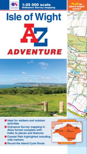
The A-Z Adventure series features the accuracy and quality of OS 1:25000 maps in a convenient book, complete with index.An innovative concept, the A-Z Adventure series utilises Ordnance Survey 1:25000 mapping in a book, therefore eliminating the need to fold and re-fold a large sheet map to the desired area. OS 1:25000 is Ordnance Survey's most detailed mapping, showing public rights of way, open access land, national parks, tourist information, car parks, public houses and camping and caravan sites.Unlike the original OS sheets, this A-Z Adventure Atlas includes a comprehensive index to towns, villages, hamlets and locations, natural features, nature reserves, car parks and youth hostels, making it easy to find the required location quickly. Each index entry has a page reference and a six figure National Grid Reference. At a book size of 240mm x 134mm it is the same size as the standard folded OS map.The Isle of Wight is one of southern England's premier holiday destinations. With its beautiful downland landscape, verdant countryside and dramatic cliffscape it is a popular choice for both walkers and riders and family seaside holidays.This A-Z Adventure Atlas of the Isle of Wight features 36 pages of continuous Ordnance Survey mapping covering the whole of the Island. The Isle of Wight Coastal Path, which circles the Island, has been highlighted in yellow with mileage markers added, making it easy to gauge distances when planning sections of the walk to enjoy. In addition, the Island's extensive network of waymarked paths and regional cycle routes have been numbered, with the Round the Island Cycle Route (67) clearly identified.Also included is advice on safety and security when walking or mountain biking and a selection of QR codes linked to useful websites.This A-Z Adventure Atlas has the accuracy and quality of OS 1:25000 mapping indexed within a book, making it the perfect companion for walkers, off-road cyclists, horse riders and anyone wishing to explore the great outdoors.Other nearby A-Z Adventure Atlases include: the New Forest, SW Coast Path (Dorset) and the South Downs Way.
Specificaties
Betrokkenen
- Auteur(s):
- Uitgeverij:
Inhoud
- Aantal bladzijden:
- 52
- Taal:
- Engels
Eigenschappen
- Productcode (EAN):
- 9781782570899
- Verschijningsdatum:
- 31/07/2015
- Uitvoering:
- Paperback
- Formaat:
- Trade paperback (VS)
- Afmetingen:
- 134 mm x 240 mm
- Gewicht:
- 102 g


Alleen bij Standaard Boekhandel
+ 22 punten op je klantenkaart van Standaard Boekhandel
Cadeau

AANGERADEN


Beoordelingen
We publiceren alleen reviews die voldoen aan de voorwaarden voor reviews. Bekijk onze voorwaarden voor reviews.