
- Afhalen na 1 uur in een winkel met voorraad
- Gratis thuislevering in België vanaf € 30
- Ruim aanbod met 7 miljoen producten
- Afhalen na 1 uur in een winkel met voorraad
- Gratis thuislevering in België vanaf € 30
- Ruim aanbod met 7 miljoen producten


Omschrijving
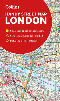
Clear and easy-to-read map of central London and surrounding area. Contains detailed mapping, presented in a handy compact format. This attractive map, ideal for both tourists and residents, and fully updated, has an extensive area of coverage and displays a wealth of detail. This map includes electric car recharging sites, fully classified roads, congestion charging zone & T-charge (Ultra Low Emission Zone from April 2019), postal districts and boundaries clearly depicted, full indexes to street names (on back of map), place names and places of interest, fully updated London underground map conveniently located on the back cover. Extends from Hampstead in the north to Clapham in the south and from Hammersmith in the west to Greenwich in the east. Scale: 1:17,500 (3.6 inches to 1 mile).
Specificaties
Betrokkenen
- Auteur(s):
- Uitgeverij:
Inhoud
- Aantal bladzijden:
- 2
- Taal:
- Engels
Eigenschappen
- Productcode (EAN):
- 9780008320584
- Verschijningsdatum:
- 1/09/2019
- Uitvoering:
- Gevouwen kaart
- Afmetingen:
- 109 mm x 188 mm
- Gewicht:
- 90 g


Alleen bij Standaard Boekhandel
+ 11 punten op je klantenkaart van Standaard Boekhandel
E-BOOK ACTIE


Beoordelingen
We publiceren alleen reviews die voldoen aan de voorwaarden voor reviews. Bekijk onze voorwaarden voor reviews.