
- Afhalen na 1 uur in een winkel met voorraad
- Gratis thuislevering in België vanaf € 30
- Ruim aanbod met 7 miljoen producten
- Afhalen na 1 uur in een winkel met voorraad
- Gratis thuislevering in België vanaf € 30
- Ruim aanbod met 7 miljoen producten


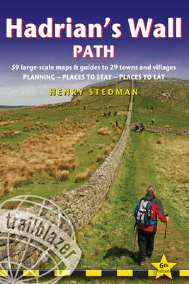
Hadrian's Wall Path
64 Large-Scale Walking Maps & Guides to 29 Towns & Villages - Planning, Places to Stay, Places to Eat
Henry Stedman
€ 18,95
+ 37 punten
Uitvoering
Omschrijving
All-in-one guide to walking Hadrian's Wall Path National Trail. Hadrian's Wall Path, 84 miles from end to end, follows the course of northern Europe's largest surviving Roman monument, a 2nd-century fortification built - in the border country between England and Scotland - on the orders of the Emperor Hadrian in AD122. Opened in 2003, the path crosses the beautiful border country between England and Scotland. It is the first National Trail to follow the course of a UNESCO World Heritage Site. This week-long walk is regarded as one of the least challenging National Trails. - 8 town plans and 59 large-scale walking maps - at just under 1:20,000 - showing route times, places to stay, points of interest and much more- Plus 6 stage maps and 1 overview map- Itineraries for all walkers - whether walking the route in its entirety over seven to eight days or sampling the highlights on day walks and short breaks- Practical information for all budgets - camping, bunkhouses, hostels, B&Bs, pubs and hotels; where to stay, where to eat, what to see, plus detailed street plans- Comprehensive public transport information - for all access points on the Hadrian's Wall Path.- Flora and fauna - four page full color flower guide, plus an illustrated section on local wildlife- Green hiking - understanding the local environment and minimizing our impact on it- Newcastle city guide- GPS waypoints. These are also downloadable from the Trailblazer website.- Includes extra colour sections: 16pp colour introduction and 16pp of colour mapping for stage sections (one stage per page) with trail profiles.- This 6th edition has been rewritten to make it even more user friendly for walkers traveling in either direction - east from Bowness-on-Solway (near Carlisle) to Newcastle as well as west from Newcastle to Bowness-on-Solway
Specificaties
Betrokkenen
- Auteur(s):
- Uitgeverij:
Inhoud
- Aantal bladzijden:
- 244
- Taal:
- Engels
- Reeks:
Eigenschappen
- Productcode (EAN):
- 9781912716128
- Verschijningsdatum:
- 1/09/2020
- Nieuwere uitgave:
- Uitvoering:
- Paperback
- Formaat:
- Trade paperback (VS)
- Afmetingen:
- 123 mm x 182 mm
- Gewicht:
- 272 g


Alleen bij Standaard Boekhandel
+ 37 punten op je klantenkaart van Standaard Boekhandel
E-BOOK ACTIE


Beoordelingen
We publiceren alleen reviews die voldoen aan de voorwaarden voor reviews. Bekijk onze voorwaarden voor reviews.