
- Afhalen na 1 uur in een winkel met voorraad
- Gratis thuislevering in België vanaf € 30
- Ruim aanbod met 7 miljoen producten
- Afhalen na 1 uur in een winkel met voorraad
- Gratis thuislevering in België vanaf € 30
- Ruim aanbod met 7 miljoen producten


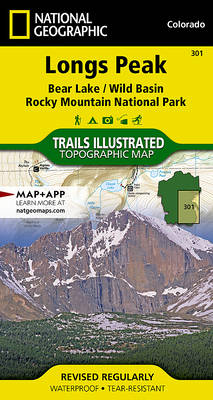
Longs Peak / Bear Lake / Wild Basin / Rocky Mountain NP
Trails Illustrated National Parks
Gevouwen kaart | Engels
€ 13,50
+ 27 punten
Omschrijving
- Waterproof - Tear-Resistant - Topographic Map
Towering over the Rocky Mountains stands the 14,259 foot high Longs Peak. National Geographic's Trails Illustrated map of Longs Peak and the surrounding south-east areas of Rocky Mountain National Park is designed to meet the needs of those who are looking for a phenomenal climbing experience as well as for all outdoor enthusiasts. Expertly researched and created in partnership with local land management agencies, this map features key points of interest including Bear Lake, Wild Basin, Moraine Park, Glacier Basin, the privately owned MacGregor Ranch Conservation Easement and the western edge of the Roosevelt National Forest.
With extensive detail of Longs Peak and miles of clearly marked trails, scenic byways lakes and creeks, the map can guide you off the beaten path and back again. The clearly marked trails include mileages between intersections. The map base includes contour lines and elevations for summits and passes. Some of the many recreation features include: visitor centers, campgrounds, backcountry campsites, trailheads, and interpretive trails.
Every Trails Illustrated map is printed on "Backcountry Tough" waterproof, tear-resistant paper. A full UTM grid is printed on the map to aid with GPS navigation.
Other features found on this map include: Longs Peak, Rocky Mountain National Park, Roosevelt National Forest.
- Map Scale = 1:25,000
- Sheet Size = 32" x 22"
- Folded Size = 4" x 7.5"
Specificaties
Betrokkenen
- Auteur(s):
- Uitgeverij:
Inhoud
- Aantal bladzijden:
- 2
- Taal:
- Engels
- Reeks:
Eigenschappen
- Productcode (EAN):
- 9781566954310
- Verschijningsdatum:
- 01/01/2019
- Uitvoering:
- Gevouwen kaart
- Formaat:
- Gelamineerd
- Afmetingen:
- 10 cm x 19 cm
- Gewicht:
- 91 g


Alleen bij Standaard Boekhandel
+ 27 punten op je klantenkaart van Standaard Boekhandel
CADEAU

AANGERADEN


Beoordelingen
We publiceren alleen reviews die voldoen aan de voorwaarden voor reviews. Bekijk onze voorwaarden voor reviews.