
- Afhalen na 1 uur in een winkel met voorraad
- Gratis thuislevering in België vanaf € 30
- Ruim aanbod met 7 miljoen producten
- Afhalen na 1 uur in een winkel met voorraad
- Gratis thuislevering in België vanaf € 30
- Ruim aanbod met 7 miljoen producten


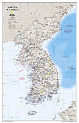
Korea schiereiland wandkaart
Wall Maps Countries & Regions
Opgerolde kaart | Engels
€ 21,95
+ 43 punten
Omschrijving
Amid increasingly combative rhetoric from Pyongyang, North Korea, do you know where its underground nuclear test site or missile launch centers are located? Are you aware that the South Korean government has begun a program to move its federal offices and personnel from Seoul to a new location? Expertly researched and designed, National Geographic's Korean Peninsula map provides this and much more information about this conflicted peninsula.
National Geographic Maps' Korean Peninsula wall map is one of the most authoritative maps of the Koreas. The peninsula's rugged terrain is expertly depicted in shaded relief, including the elevation of prominent mountains and ocean depths in meters. This edition clearly portrays both countries and uses the latest system for transcribing South Korean place-names from the Korean alphabet. In great detail, it delineates the latest administrative divisions of both countries along with the July 27, 1953 Military Demarcation Line--the historic demarcation line between the two Koreas. The map also portrays the transportation grid of both countries, including South Korea's high-speed passenger railway network.
The signature Classic style map uses a bright, easy to read color palette featuring blue oceans and stunning shaded relief that has been featured on National Geographic wall maps for over 75 years.
The map is packaged in a two inch diameter tube with a label showing a thumbnail of the map with dimensions and other pertinent information.
- Map Scale = 1:1,357,000
- Sheet Size = 23.25" x 35.75"
Specificaties
Betrokkenen
- Auteur(s):
- Uitgeverij:
Inhoud
- Aantal bladzijden:
- 1
- Taal:
- Engels
- Reeks:
Eigenschappen
- Productcode (EAN):
- 9781597755658
- Verschijningsdatum:
- 5/04/2023
- Uitvoering:
- Opgerolde kaart
- Afmetingen:
- 59 cm x 91 cm
- Gewicht:
- 162 g


Alleen bij Standaard Boekhandel
+ 43 punten op je klantenkaart van Standaard Boekhandel
CADEAU

AANGERADEN


Beoordelingen
We publiceren alleen reviews die voldoen aan de voorwaarden voor reviews. Bekijk onze voorwaarden voor reviews.