
- Afhalen na 1 uur in een winkel met voorraad
- Gratis thuislevering in België vanaf € 30
- Ruim aanbod met 7 miljoen producten
- Afhalen na 1 uur in een winkel met voorraad
- Gratis thuislevering in België vanaf € 30
- Ruim aanbod met 7 miljoen producten


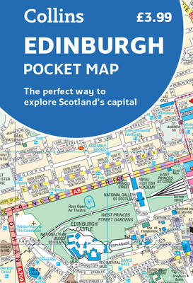
Edinburgh Pocket Map
The Perfect Way to Explore Edinburgh
Gevouwen kaart | Engels
€ 5,95
+ 11 punten
Omschrijving
Handy little full colour Collins map of central Edinburgh with a high level of detail. Clear mapping from Leith in the north to The Meadows in the south, and Edinburgh Zoo in the west to Holyrood Park in the east. Map at a scale of 1:11,000 (6 inches to 1 mile).Clear, detailed, full colour Collins mapping is presented in a handy format ideal for the pocket or handbag. It is excellent value and covers the most visited area of central Edinburgh. It is an essential buy for tourists and residents alike.This map includes: - Detailed central area map- Around Edinburgh map extending to airport, Pentland Hills and Forth Road Bridge- Tourist locations- Tram, Train and bus stations- Listing of major places to visit, with additional details for Edinburgh Castle and Holyroodhouse- Detailed street index
Specificaties
Betrokkenen
- Auteur(s):
- Uitgeverij:
Inhoud
- Aantal bladzijden:
- 2
- Taal:
- Engels
Eigenschappen
- Productcode (EAN):
- 9780008368272
- Verschijningsdatum:
- 1/05/2020
- Uitvoering:
- Gevouwen kaart
- Afmetingen:
- 89 mm x 140 mm
- Gewicht:
- 40 g


Alleen bij Standaard Boekhandel
+ 11 punten op je klantenkaart van Standaard Boekhandel
CADEAU

AANGERADEN


Beoordelingen
We publiceren alleen reviews die voldoen aan de voorwaarden voor reviews. Bekijk onze voorwaarden voor reviews.