
- Afhalen na 1 uur in een winkel met voorraad
- Gratis thuislevering in België vanaf € 30
- Ruim aanbod met 7 miljoen producten
- Afhalen na 1 uur in een winkel met voorraad
- Gratis thuislevering in België vanaf € 30
- Ruim aanbod met 7 miljoen producten


Omschrijving
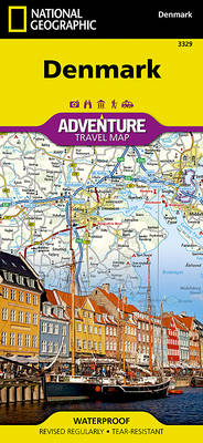
Explore Denmark's more than 100 islands, the largest of which are connected by a series of long bridges and tunnels with National Geographic's Denmark Adventure Map. Designed to meet the needs of adventure travelers with its detailed, accurate information, this map includes the location of cities and towns with a user-friendly index and a clearly marked road network complete with distances and designations for motorways, major routes, and roads. In addition, side roads and tracks are shown for those seeking to explore off the beaten path. Hundreds of points of interest that highlight the diverse, unique, and exotic destinations within the country such as national parks and reserves, wildlife parks, World Heritage sites, and archeological sites. Important travel aids like airports, airfields, railroads, ferry routes, and lighthouses are included as well.
Specificaties
Betrokkenen
- Auteur(s):
- Uitgeverij:
Inhoud
- Aantal bladzijden:
- 1
- Taal:
- Engels
- Reeks:
Eigenschappen
- Productcode (EAN):
- 9781566957601
- Verschijningsdatum:
- 1/12/2022
- Uitvoering:
- Gevouwen kaart
- Formaat:
- Gelamineerd
- Afmetingen:
- 11 cm x 24 cm
- Gewicht:
- 94 g


Alleen bij Standaard Boekhandel
+ 31 punten op je klantenkaart van Standaard Boekhandel
Cadeau

AANGERADEN


Beoordelingen
We publiceren alleen reviews die voldoen aan de voorwaarden voor reviews. Bekijk onze voorwaarden voor reviews.