
- Afhalen na 1 uur in een winkel met voorraad
- Gratis thuislevering in België vanaf € 30
- Ruim aanbod met 7 miljoen producten
- Afhalen na 1 uur in een winkel met voorraad
- Gratis thuislevering in België vanaf € 30
- Ruim aanbod met 7 miljoen producten


Omschrijving
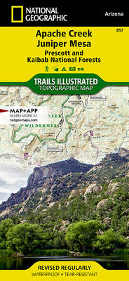
- Waterproof - Tear-Resistant - Topographic Map
Outdoor enthusiasts adventuring through the northern half of Prescott National Forest will find National Geographic's Trails Illustrated map of Apache Creek and Juniper Mesa an essential travel companion. Covering the area with unmatched detail, this comprehensive map was expertly researched and created in cooperation with the U.S. Forest Service and others. Some of the recreation hotspots shown are Apache Creek, Juniper Mesa, Woodchute and Granite Mountain Wilderness areas, Upper Verde River State Wildlife Area, Black Hills and Verde Wild and Scenic River.
Explore the area by following mapped trails, clearly labeled for motorized or non-motorized use, including parts of the Great Western Trail, which are highlighted. To aid in your navigation, the map displays contour lines, elevations, labeled peaks, summits and mesas, water features, areas of wooded cover, selected waypoints, numbered Forest Service roads and clearly marked areas of public and private land. Additionally shown is a complete road network including scenic byways, as well as the Chino Valley area. Other recreation features pinpointed are trailheads, campgrounds, ATV areas, motorcycle trails, shooting ranges, boat launches, picnic areas and scenic viewpoints. Background information about the various public lands, a recreation overview, safety tips and essential contact information are also provided.
Every Trails Illustrated map is printed on "Backcountry Tough" waterproof, tear-resistant paper. A full UTM grid is printed on the map to aid with GPS navigation.
Other features found on this map include: Big Chino Valley, Chino Valley, Granite Mountain, Granite Mountain (AZ) Wilderness, Juniper Mesa Wilderness, Juniper Mountains, Kaibab National Forest, Lonesome Valley, Prescott National Forest, Prescott Valley, Santa Maria Mountains.
- Map Scale = 1:70,000
- Sheet Size = 25.5" x 37.75"
- Folded Size = 4.25" x 9.25"
Specificaties
Betrokkenen
- Auteur(s):
- Uitgeverij:
Inhoud
- Aantal bladzijden:
- 2
- Taal:
- Engels
- Reeks:
Eigenschappen
- Productcode (EAN):
- 9781566955164
- Verschijningsdatum:
- 1/01/2020
- Uitvoering:
- Gevouwen kaart
- Formaat:
- Gelamineerd
- Afmetingen:
- 11 cm x 24 cm
- Gewicht:
- 91 g


Alleen bij Standaard Boekhandel
+ 31 punten op je klantenkaart van Standaard Boekhandel
CADEAU

AANGERADEN


Beoordelingen
We publiceren alleen reviews die voldoen aan de voorwaarden voor reviews. Bekijk onze voorwaarden voor reviews.