
- Afhalen na 1 uur in een winkel met voorraad
- Gratis thuislevering in België vanaf € 30
- Ruim aanbod met 7 miljoen producten
- Afhalen na 1 uur in een winkel met voorraad
- Gratis thuislevering in België vanaf € 30
- Ruim aanbod met 7 miljoen producten


Reeksen: boeken uit de reeks National Geographic Topographic Map Guide

-
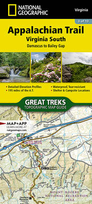
Appalachian Trail: Damascus to Bailey Gap Map [Virginia]
- Engels
- The Damascus to Bailey Gap Topographic Map Guide makes a perfect traveling companion when traversing the southwest Virginia section of the Appalachian... Lees meer
€ 15,95Levering 1 à 2 weken€ 15,95Levering 1 à 2 weken -
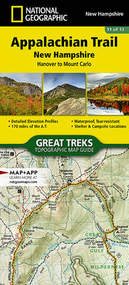
Appalachian Trail: Hanover to Mount Carlo Map [New Hampshire]
- Engels
- The Hanover to Mount Carlo Topographic Map Guide makes a perfect traveling companion when traversing the New Hampshire section of the Appalachian Trai... Lees meer
€ 15,95Levering 1 à 2 weken€ 15,95Levering 1 à 2 weken -
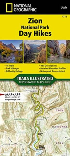
Zion National Park Day Hikes Map
- Engels
- - Waterproof - Tear-Resistant - Topographic Map Zion was officially established as a national park in 1919. One of only two scenic rivers in Utah runs... Lees meer
€ 20,95Levering 1 à 2 weken€ 20,95Levering 1 à 2 weken -

Pacific Crest Trail: San Gabriel and San Bernardino Mountains Map [Vasquez Rocks to San Gorgonio Pass]
- Engels
- - Waterproof - Tear-Resistant - Topographic Map The Pacific Crest Trail (PCT) in this part of southern California travels through the scrub-covered Si... Lees meer
€ 20,95Levering 1 à 2 weken€ 20,95Levering 1 à 2 weken -
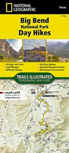
Big Bend National Park Day Hikes Map
- Engels
- - Waterproof - Tear-Resistant - Topographic Map Big Bend National Park is named for the large bend in the Rio Grande forming the park's southern bound... Lees meer
€ 20,95Levering 1 à 2 weken€ 20,95Levering 1 à 2 weken -
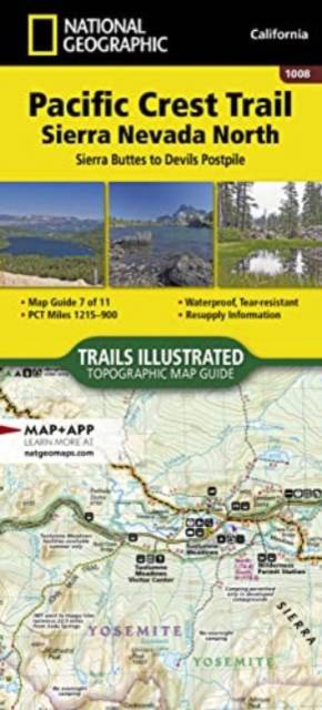
Pacific Crest Trail: Sierra Nevada North Map [Sierra Buttes to Devil's Postpile]
- Engels
- The Pacific Crest Trail (PCT) mapped in the Sierra Nevada North Topographic Map Guide travels through subalpine forests and volcanic rock formations, ... Lees meer
€ 15,95Levering 1 à 2 weken€ 15,95Levering 1 à 2 weken -
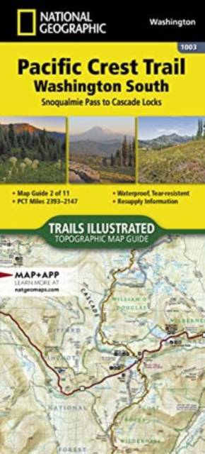
Pacific Crest Trail: Washington South Map [Snoqualmie Pass to Cascade Locks]
- Engels
- - Waterproof - Tear-Resistant - Topographic Map The Washington South Topographic Map Guide follows the Pacific Crest Trail (PCT) as it travels through... Lees meer
€ 20,95Levering 1 à 2 weken€ 20,95Levering 1 à 2 weken -
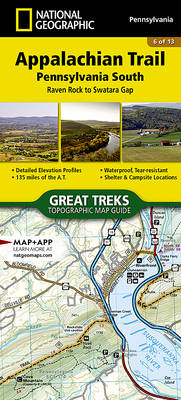
Appalachian Trail: Raven Rock to Swatara Gap Map [Pennsylvania]
- Engels
- The Raven Rock to Swatara Gap Topographic Map Guide makes a perfect traveling companion when traversing the southeastern Pennsylvania section of the A... Lees meer
€ 15,95Levering 1 à 2 weken€ 15,95Levering 1 à 2 weken -
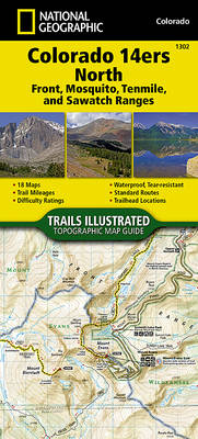
Colorado 14ers North Map [Sawatch, Mosquito, and Front Ranges]
- Engels
- Colorado has the highest mean elevation of any state in the United States. It's home to 58 mountain peaks higher than 14,000 feet—more than any other ... Lees meer
€ 15,95Levering 1 à 2 weken€ 15,95Levering 1 à 2 weken -
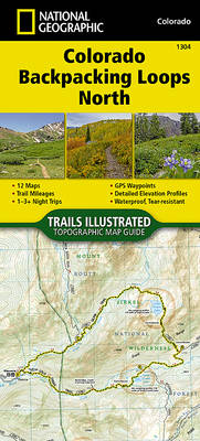
Colorado Backpack Loops North Map
- Engels
- Colorado is renowned for its outdoor recreational opportunities. One of these pastimes is, of course, backcountry hiking. The Colorado Backpack Loops ... Lees meer
€ 15,95Levering 1 à 2 weken€ 15,95Levering 1 à 2 weken -
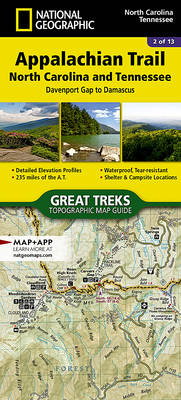
Appalachian Trail: Davenport Gap to Damascus Map [North Carolina, Tennessee]
- Engels
- The Davenport Gap to Damascus Topographic Map Guide makes a perfect traveling companion when traversing the northeastern Tennessee and western North C... Lees meer
€ 15,95Levering 1 à 2 weken€ 15,95Levering 1 à 2 weken -
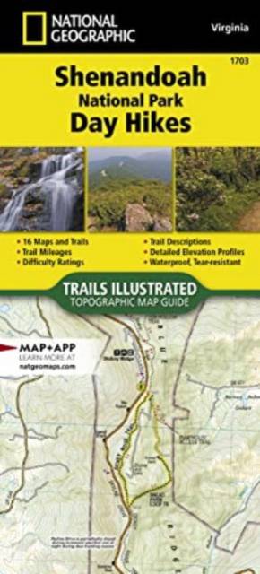
Shenandoah National Park Day Hikes Map
- Engels
- - Waterproof - Tear-Resistant - Topographic Map Shenandoah National Park rises above the Virginia Piedmont to its east and the Shenandoah Valley to it... Lees meer
€ 20,95Levering 1 à 2 weken€ 20,95Levering 1 à 2 weken -
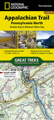
Appalachian Trail: Swatara Gap to Delaware Water Gap Map [Pennsylvania]
- Engels
- The Swatara Gap to Delaware Water Gap Topographic Map Guide makes a perfect traveling companion when traversing the northeastern Pennsylvania section ... Lees meer
€ 15,95Levering 1 à 2 weken€ 15,95Levering 1 à 2 weken -
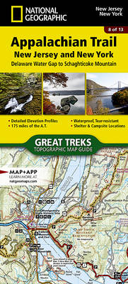
Appalachian Trail: Delaware Water Gap to Schaghticoke Mountain Map [New Jersey, New York]
- Engels
- The Delaware Water Gap to Schaghticoke Mountain Topographic Map Guide makes a perfect traveling companion when traversing the New Jersey and New York ... Lees meer
€ 15,95Levering 1 à 2 weken€ 15,95Levering 1 à 2 weken -
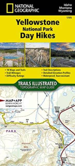
Yellowstone National Park Day Hikes Map
- Engels
- - Waterproof - Tear-Resistant - Topographic Map Yellowstone is the wild heart of America! Established in 1872, it's our first National Park and the bi... Lees meer
€ 20,95Levering 1 à 2 weken€ 20,95Levering 1 à 2 weken -
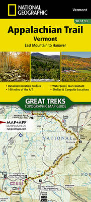
Appalachian Trail: East Mountain to Hanover Map [Vermont]
- Engels
- The East Mountain to Hanover Topographic Map Guide makes a perfect traveling companion when traversing the Vermont section of the Appalachian Trail (A... Lees meer
€ 15,95Levering 1 à 2 weken€ 15,95Levering 1 à 2 weken -
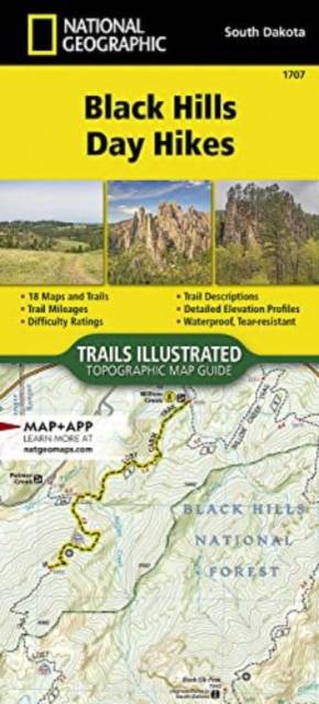
Black Hills Day Hikes Map
- Engels
- - Waterproof - Tear-Resistant - Topographic Map Considered a sacred region by many Native American peoples of the Northern Great Plains, the Black Hil... Lees meer
€ 20,95Levering 1 à 2 weken€ 20,95Levering 1 à 2 weken -
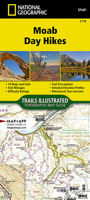
Moab Day Hikes Map
- Engels
- - Waterproof - Tear-Resistant - Topographic Map From Jurassic-era dunes and prehistoric petroglyphs, to amber-tinted cliffs and spires, Moab offers a ... Lees meer
€ 22,45Levering 1 à 2 weken€ 22,45Levering 1 à 2 weken -
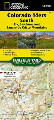
Colorado 14ers South Map [San Juan, Elk, and Sangre de Cristo Mountains]
- Engels
- Colorado has the highest mean elevation of any state in the United States. It's home to 58 mountain peaks higher than 14,000 feet—more than any other ... Lees meer
€ 15,95Levering 1 à 2 weken€ 15,95Levering 1 à 2 weken -
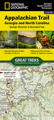
Appalachian Trail: Springer Mountain to Davenport Gap Map [Georgia, North Carolina, Tennessee]
- Engels
- The Springer Mountain to Davenport Gap Topographic Map Guide makes a perfect traveling companion when traversing the Georgia, southeastern Tennessee a... Lees meer
€ 15,95Levering 1 à 2 weken€ 15,95Levering 1 à 2 weken -
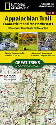
Appalachian Trail: Schaghticoke Mountain to East Mountain Map [Connecticut, Massachusetts]
- Engels
- The Schaghticoke Mountain to East Mountain Topographic Map Guide makes a perfect traveling companion when traversing the Connecticut and Massachusetts... Lees meer
€ 15,95Levering 1 à 2 weken€ 15,95Levering 1 à 2 weken -
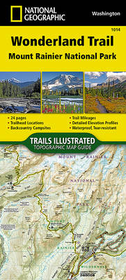
Wonderland Trail Map
- Engels
- - Waterproof - Tear-Resistant - Topographic Map The Wonderland Trail encircles Mount Rainier and was completed in 1915 by volunteers and designated a ... Lees meer
€ 20,95Levering 1 à 2 weken€ 20,95Levering 1 à 2 weken -
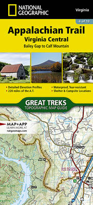
Appalachian Trail: Bailey Gap to Calf Mountain Map [Virginia]
- Engels
- The Bailey Gap to Calf Mountain Topographic Map Guide makes a perfect traveling companion when traversing the central Virginia section of the Appalach... Lees meer
€ 15,95Levering 1 à 2 weken€ 15,95Levering 1 à 2 weken -
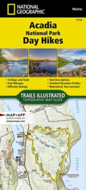
Acadia National Park Day Hikes Map
- Engels
- - Waterproof - Tear-Resistant - Topographic Map Preserving almost 50,000 acres of islands and peninsula along the jagged north-central coast of Maine,... Lees meer
€ 20,95Levering 1 à 2 weken€ 20,95Levering 1 à 2 weken