
Bedankt voor het vertrouwen het afgelopen jaar! Om jou te bedanken bieden we GRATIS verzending (in België) aan op alles gedurende de hele maand januari.
- Afhalen na 1 uur in een winkel met voorraad
- In januari gratis thuislevering in België
- Ruim aanbod met 7 miljoen producten
Bedankt voor het vertrouwen het afgelopen jaar! Om jou te bedanken bieden we GRATIS verzending (in België) aan op alles gedurende de hele maand januari.
- Afhalen na 1 uur in een winkel met voorraad
- In januari gratis thuislevering in België
- Ruim aanbod met 7 miljoen producten


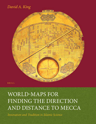
World-Maps for Finding the Direction and Distance to Mecca
Innovation and Tradition in Islamic Science
David King
€ 90,95
+ 181 punten
Omschrijving
Two remarkable Iranian world-maps were discovered in 1989 and 1995. Both are made of brass and date from 17th-century Iran. Mecca is at the centre and a highly sophisticated longitude and latitude grid enables the user to determine the direction and distance to Mecca for anywhere in the world between Andalusia and China. Prior to the discovery of these maps it was thought that such cartographic grids were conceived in Europe ca. 1910. This richly-illustrated book presents an overview of the ways in which Muslims over the centuries have determined the sacred direction towards Mecca (qibla) and then describes the two world-maps in detail. The author shows that the geographical data derives from a 15th-century Central Asian source and that the mathematics underlying the grid was developed in 9th-century Baghdad.
Specificaties
Betrokkenen
- Auteur(s):
- Uitgeverij:
Inhoud
- Aantal bladzijden:
- 670
- Taal:
- Engels
- Reeks:
- Reeksnummer:
- nr. 36
Eigenschappen
- Productcode (EAN):
- 9789004259874
- Verschijningsdatum:
- 1/01/1999
- Uitvoering:
- Paperback
- Formaat:
- Trade paperback (VS)
- Afmetingen:
- 210 mm x 270 mm
- Gewicht:
- 1437 g


Alleen bij Standaard Boekhandel
+ 181 punten op je klantenkaart van Standaard Boekhandel
SOLDEN


Beoordelingen
We publiceren alleen reviews die voldoen aan de voorwaarden voor reviews. Bekijk onze voorwaarden voor reviews.