
- Afhalen na 1 uur in een winkel met voorraad
- Gratis thuislevering in België vanaf € 30
- Ruim aanbod met 7 miljoen producten
- Afhalen na 1 uur in een winkel met voorraad
- Gratis thuislevering in België vanaf € 30
- Ruim aanbod met 7 miljoen producten


Omschrijving
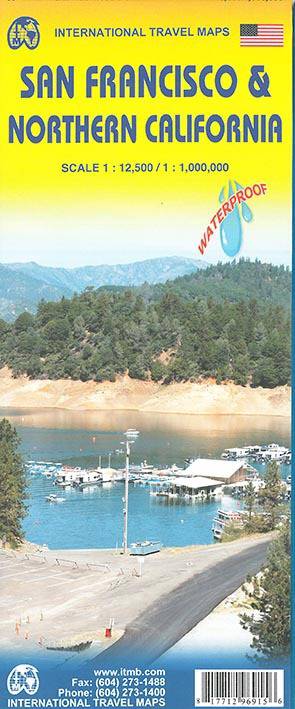
Stadsplan San Francisco - Wegenkaart Californië Noord
On one side is a street plan of San Francisco, extending from the Bay to the Pacific and further south, beyond Haight-Ashbury and Castro to, on the Pacific side, the Zoo and Lakeside and on the Bay side to the UCSF Campus in Mission Bay. Names of districts are clearly shown, with main traffic arteries highlighted and one way streets marked. Lines and stops of the transit system, including the cable car and the vintage tram lines, are also very well presented. The colouring indicates the city’s numerous parks and green spaces. The map highlights locations of various places of interest and numerous hotels. Also included are a diagram of the Bay Area Rapid Transit System and a small road map of the region.
On the reverse is a road map of northern California extending south to Santa Barbara and north to Crater Lake National Park in Oregon. Altitude colouring with elevation in feet presents the topography. The map shows the region’s road and rail networks, and highlights national parks and other protected areas, campsites and various places of interest.
Specificaties
Betrokkenen
- Auteur(s):
- Uitgeverij:
Inhoud
- Taal:
- Engels
Eigenschappen
- Productcode (EAN):
- 9781771296915
- Verschijningsdatum:
- 23/06/2015
- Nieuwere uitgave:
- Uitvoering:
- Gevouwen kaart
- Formaat:
- Gelamineerd
- Afmetingen:
- 10 cm x 25 cm
- Gewicht:
- 75 g


Alleen bij Standaard Boekhandel
+ 23 punten op je klantenkaart van Standaard Boekhandel
AANGERADEN


Beoordelingen
We publiceren alleen reviews die voldoen aan de voorwaarden voor reviews. Bekijk onze voorwaarden voor reviews.