
Bedankt voor het vertrouwen het afgelopen jaar! Om jou te bedanken bieden we GRATIS verzending (in België) aan op alles gedurende de hele maand januari.
- Afhalen na 1 uur in een winkel met voorraad
- In januari gratis thuislevering in België
- Ruim aanbod met 7 miljoen producten
Bedankt voor het vertrouwen het afgelopen jaar! Om jou te bedanken bieden we GRATIS verzending (in België) aan op alles gedurende de hele maand januari.
- Afhalen na 1 uur in een winkel met voorraad
- In januari gratis thuislevering in België
- Ruim aanbod met 7 miljoen producten


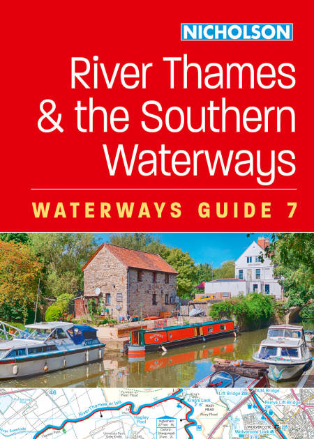
River Thames and the Southern Waterways E-BOOK
For everyone with an interest in Britain’s canals and rivers
€ 18,48
+ 18 punten
Omschrijving
The bestselling guides to Britain’s canals and rivers for 50 years.
For all users of the inland waterways including boaters, walkers, cyclists and visitors, this established, popular and practical guide covers the canals and waterways between Exeter and the River Thames.
Waterways covered in this guide – Basingstoke Canal, Bridgwater & Taunton Canal, Grand Western Canal, Exeter Ship Canal, Kennet & Avon Canal, River Thames, Wey & Godalming Navigations.
The up-to-date, detailed maps clearly show the location of essential features such as locks, towpaths and boating facilities, as well as pubs, shops and restaurants in the area. There are comprehensive navigational notes and descriptive text on the history of each canal, and on local services and places of interest, for which postcodes are included – ideal for use with sat-navs. Scale: 2 inches = 1 mile, 3 cm = 1 km.
This practical A5 guide features 'lie flat' spiral binding and 'book mark' back cover flap for ease of reference.
Specificaties
Betrokkenen
- Uitgeverij:
Inhoud
- Aantal bladzijden:
- 232
- Taal:
- Engels
- Reeks:
Eigenschappen
- Productcode (EAN):
- 9780008733193
- Verschijningsdatum:
- 26/02/2025
- Uitvoering:
- E-book
- Beveiligd met:
- Adobe DRM
- Formaat:


Alleen bij Standaard Boekhandel
+ 18 punten op je klantenkaart van Standaard Boekhandel
SOLDEN


Beoordelingen
We publiceren alleen reviews die voldoen aan de voorwaarden voor reviews. Bekijk onze voorwaarden voor reviews.