
- Afhalen na 1 uur in een winkel met voorraad
- Gratis thuislevering in België vanaf € 30
- Ruim aanbod met 7 miljoen producten
- Afhalen na 1 uur in een winkel met voorraad
- Gratis thuislevering in België vanaf € 30
- Ruim aanbod met 7 miljoen producten


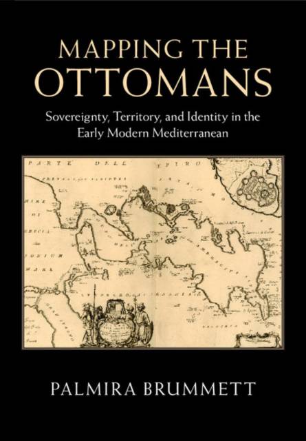
Mapping the Ottomans
Sovereignty, Territory, and Identity in the Early Modern Mediterranean
Palmira Brummett
Hardcover | Engels
€ 82,45
+ 164 punten
Uitvoering
Eenvoudig bestellen
Veilig betalen


Gratis thuislevering vanaf € 30 (via bpost)
Gratis levering in je Standaard Boekhandel
Omschrijving
Simple paradigms of Muslim-Christian confrontation and the rise of Europe in the seventeenth century do not suffice to explain the ways in which European mapping envisioned the "Turks" in image and narrative. Rather, maps, travel accounts, compendia of knowledge, and other texts created a picture of the Ottoman Empire through a complex layering of history, ethnography, and eyewitness testimony, which juxtaposed current events to classical and biblical history; counted space in terms of peoples, routes, and fortresses; and used the land and seascapes of the map to assert ownership, declare victory, and embody imperial power's reach. Enriched throughout by examples of Ottoman self-mapping, this book examines how Ottomans and their empire were mapped in the narrative and visual imagination of early modern Europe's Christian kingdoms. The maps serve as centerpieces for discussions of early modern space, time, borders, stages of travel, information flows, invocations of authority, and cross-cultural relations.
Specificaties
Betrokkenen
- Auteur(s):
- Uitgeverij:
Inhoud
- Aantal bladzijden:
- 398
- Taal:
- Engels
Eigenschappen
- Productcode (EAN):
- 9781107090774
- Verschijningsdatum:
- 19/05/2015
- Uitvoering:
- Hardcover
- Formaat:
- Genaaid
- Afmetingen:
- 180 mm x 254 mm
- Gewicht:
- 861 g


Alleen bij Standaard Boekhandel
+ 164 punten op je klantenkaart van Standaard Boekhandel
CADEAU

AANGERADEN


Beoordelingen
We publiceren alleen reviews die voldoen aan de voorwaarden voor reviews. Bekijk onze voorwaarden voor reviews.