
- Afhalen na 1 uur in een winkel met voorraad
- Gratis thuislevering in België vanaf € 30
- Ruim aanbod met 7 miljoen producten
- Afhalen na 1 uur in een winkel met voorraad
- Gratis thuislevering in België vanaf € 30
- Ruim aanbod met 7 miljoen producten


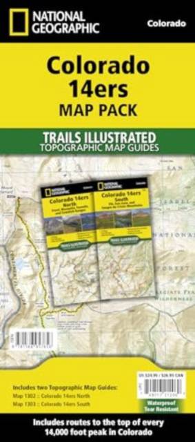
Colorado 14ers [Map Pack Bundle]
Trails Illustrated Maps
Gevouwen kaart | Engels
€ 34,95
+ 69 punten
Omschrijving
- Waterproof - Tear-Resistant - Topographic Maps
Colorado has the highest mean elevation of any state in the United States. It's home to 58 mountain peaks higher than 14,000 feet--more than any other state in the U.S--making it a mountain sports mecca. "Bagging" these fourteeners is a goal for many Coloradans and visitors to the state--and for some, it's an obsession.
Each map page provides accurate trail statistics including trail mileages, total elevation gain and loss, trailhead elevations and elevations at trail junctions, and directions to trailheads. Route information includes climbing class (i.e. difficulty rating) and points of reference along the route. The maps include both 2WD and 4WD trailhead locations for the standard, recommended route.
The Map Pack includes every 14,000 peak in Colorado in a single, easy to purchase bundle.
The Colorado 14ers Map Pack includes:
- Map 1302:: Colorado 14ers North
- Map 1303:: Colorado 14ers South
More convenient and easier to use than folded maps, but just as compact and lightweight, National Geographic's Topographic Map Guide booklets are printed on 'Backcountry Tough' waterproof, tear-resistant paper with stainless steel staples. A full UTM grid is printed on the map to aid with GPS navigation.
- Map Scale = 1:40,680 & 1:63,360
- Folded Size = 4.25" x 9.38"
Specificaties
Betrokkenen
- Auteur(s):
- Uitgeverij:
Inhoud
- Aantal bladzijden:
- 88
- Taal:
- Engels
- Reeks:
Eigenschappen
- Productcode (EAN):
- 9781566957656
- Verschijningsdatum:
- 1/01/2022
- Uitvoering:
- Gevouwen kaart
- Afmetingen:
- 94 mm x 251 mm
- Gewicht:
- 181 g


Alleen bij Standaard Boekhandel
+ 69 punten op je klantenkaart van Standaard Boekhandel
Cadeau

AANGERADEN


Beoordelingen
We publiceren alleen reviews die voldoen aan de voorwaarden voor reviews. Bekijk onze voorwaarden voor reviews.