
- Afhalen na 1 uur in een winkel met voorraad
- Gratis thuislevering in België vanaf € 30
- Ruim aanbod met 7 miljoen producten
- Afhalen na 1 uur in een winkel met voorraad
- Gratis thuislevering in België vanaf € 30
- Ruim aanbod met 7 miljoen producten


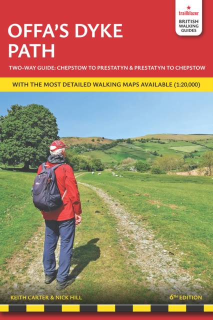
Offa's Dyke Path
British Walking Guide: Planning, Places to Stay, Places to Eat; Includes 98 Large-Scale Walking Maps
Keith Carter, Nick Hill
€ 21,50
+ 43 punten
Uitvoering
Eenvoudig bestellen
Veilig betalen


Gratis thuislevering vanaf € 30 (via bpost)
Gratis levering in je Standaard Boekhandel
Omschrijving
The Offa's Dyke Path is a superb national trail that runs from the North Wales coast to the Severn Estuary following the line of Offa's Dyke, an impressive 8th century earthwork along the English/Welsh border. The ever-changing landscape - the Clwydian Range, the Shropshire Hills, the Black Mountains and the Wye Valley - is steeped in history and legend providing 177 miles of fascinating walking. This is an all-in-one two-way hiking route guide, maps and accommodations for the 177-mile Offa's Dyke Path in Wales, which runs along the border with England. Includes 87 large-scale walking maps (3 1/8 inches to 1 mile); 11 town maps and 15 overview maps. Full details of all accommodations and campsites, restaurants and pubs; plus full public transport information. Includes day-walks.
- Two-way guide - walk from north to south (Prestatyn to Chepstow) or south to north (Chepstow to Prestatyn)
- 11 town plans and 87 large-scale walking maps - at just under 1:20,000 - showing route times, places to stay, points of interest and much more
- Plus 14 overview maps Itineraries for all walkers - whether walking the route in its entirety over seven to eight days or sampling the highlights on day walks and short breaks
- Practical information for all budgets - camping, bunkhouses, hostels, B&Bs, pubs and hotels - where to stay, where to eat, what to see, plus detailed street plans
- Comprehensive public transport information - for all access points on the path.
- Flora and fauna - four page flower guide, plus an illustrated section on local wildlife
- Green hiking - understanding the local environment and minimizing our impact on it
- With downloadable gps waypoints now also with what3words references
- Includes extra colour sections: 16pp colour introduction and 16pp of colour mapping for stage sections (one stage per page) with trail profiles.
Specificaties
Betrokkenen
- Auteur(s):
- Uitgeverij:
Inhoud
- Aantal bladzijden:
- 256
- Taal:
- Engels
- Reeks:
Eigenschappen
- Productcode (EAN):
- 9781912716425
- Verschijningsdatum:
- 31/03/2026
- Uitvoering:
- Paperback
- Formaat:
- Trade paperback (VS)
- Afmetingen:
- 118 mm x 180 mm
- Gewicht:
- 294 g


Alleen bij Standaard Boekhandel
+ 43 punten op je klantenkaart van Standaard Boekhandel
CADEAU

AANGERADEN


Beoordelingen
We publiceren alleen reviews die voldoen aan de voorwaarden voor reviews. Bekijk onze voorwaarden voor reviews.